Pictures of England

Search:

Historic Towns & Picturesque Villages

Recommended Towns & Villages near Allenheads

Nent Valley, Nenthead, Cumbria.

Nenthead (14 Pictures)

a Picturesque Village in the county of Cumbria (5.0 miles, 8.1 km, direction W)

Nestling beside the sparkling River Nent, Nenthead lies on Alston Moor, in a lonely remote North Pennine Area of Outstanding Natural Beauty, between the pleasant market town of Alston and the Killhope lead mining museum...

A view in the central business district, Allendale Town, Northumberland

Allendale Town (23 Pictures)

a Picturesque Village in the county of Northumberland (6.6 miles, 10.6 km, direction N)

This picturesque Northumberland village enjoys a lovely location in the fine hill and dale countryside of the beautiful East Allen Valley...

Garrigill in Cumbria

Garrigill (13 Pictures)

in the county of Cumbria (7.5 miles, 12.1 km, direction W)

This delightful place can be found on the banks of the South Tyne River, it is also on the route of the arduous Pennine Way surrounded by numerous beauty spots. The village.....

Blanchland, Northumberland

Blanchland (38 Pictures)

a Picturesque Village in the county of Northumberland (7.6 miles, 12.2 km, direction NE)

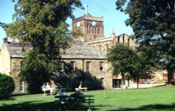
Blanchland is a small picturesque village nestled beside the river in the Derwent Valley within the North Pennines Area Of Outstanding Natural Beauty. It is surrounded by.....

St Augustine's Church, Alston, Cumbria

Alston (32 Pictures)

a Historic Market Town in the county of Cumbria (8.8 miles, 14.2 km, direction W)

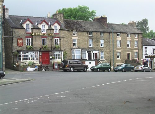
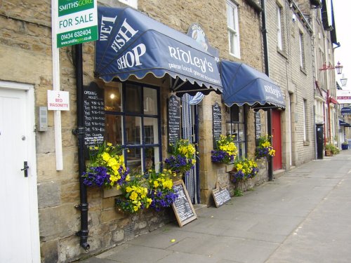
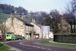
At a height of over 1,000 feet in the far reaches of the Pennines, this is one of England's highest market towns. Alston is a lively bustling place of steeply rising narrow.....

Where sheep shall graze

Stanhope (27 Pictures)

in the county of County Durham (9.1 miles, 14.6 km, direction SE)

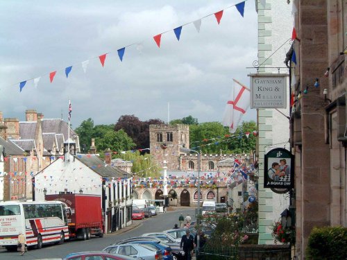
This is a lovely, bustling little town is set amidst the charm of Weardale, it is almost entirely built of stone particularly around the old Market Square, dominated by a fine stone cross...

The Church at Whitfield, Northumberland

Whitfield (2 Pictures)

a Picturesque Village in the county of Northumberland (9.5 miles, 15.2 km, direction NW)

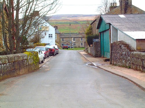
This is a picturesque village lying amongst sprawling open countryside criss crossed by dancing streams, tributaries of the River West Allen...

Low Force, Forest- in-Teesdale, County Durham

Forest-in-Teesdale (30 Pictures)

in the county of County Durham (9.8 miles, 15.7 km, direction S)

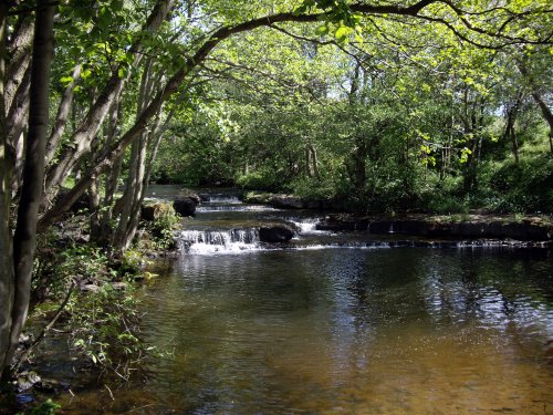
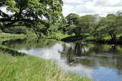
It's landscape, possessed of a wild untamed beauty, highlighted by the meandering River Tees, has a few ancient farmhouses and old stone cottages...

A view of Hexham in Northumberland. Fog over the River Tyne.

Hexham (35 Pictures)

a Historic Market Town in the county of Northumberland (12.5 miles, 20.1 km, direction N)

Historic market town where for centuries the sheep and cattle farmers of Northumberland gathered for the Tuesday market beside Hexham Abbey...

Wolsingham

Wolsingham (18 Pictures)

a Historic Market Town in the county of County Durham (14.2 miles, 22.9 km, direction E)

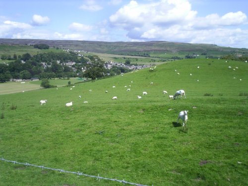
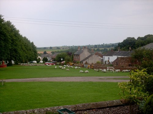
This is a lovely village lying on the edge of the North Pennines in an area of great scenic beauty. It is a wild and beautiful landscape dotted only by scattered farms with meadows full of grazing sheep and cattle...

Corbridge, Northumberland

Corbridge (31 Pictures)

a Picturesque Village in the county of Northumberland (14.3 miles, 23.0 km, direction NE)

Located in Northumberland, Corbridge is a historic market town with Roman connections. It features charming streets, historic buildings, and the Corbridge Roman Town archaeological site...

St.Michael's Church in the village of WALL in the county of NORTHUMBERLAND - August 2003

Wall (1 Pictures)

a Picturesque Village in the county of Northumberland (15.0 miles, 24.2 km, direction N)

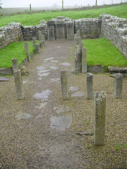
The village of Wall lies in the high uplands of Northumberland in spacious countryside bordered by the rivers South Tyne and North Tyne, close to Chester's Fort on historic Hadrian's Wall...

Chollerford Bridge over the North Tyne, Northumberland

Chollerford (26 Pictures)

in the county of Northumberland (16.1 miles, 25.9 km, direction N)

Chollerford is a delightful village destination. It is a popular base for tourists visiting Hadrian's Wall and Chester Fort. The region is also popular with keen fishermen, with.....

A picture of Dufton

Dufton (7 Pictures)

in the county of Cumbria (16.4 miles, 26.4 km, direction SW)

..

Fall Berries at Craigside, England

Craigside (2 Pictures)

in the county of County Durham (17.5 miles, 28.2 km, direction E)

..

Boroughgate, the towns main street. Appleby-in-Westmoorland, Cumbria

Appleby-in-Westmorland (6 Pictures)

a Historic Market Town in the county of Cumbria (18.9 miles, 30.4 km, direction SW)

Appleby, is situated in the valley of the River Eden near to Hoff Beck, stunningly beautiful, it is an ideal centre for both walking and touring...

Barnard Castle, County Durham

Barnard Castle (43 Pictures)

a Historic Market Town in the county of County Durham (21.4 miles, 34.4 km, direction SE)

..

Escomb Saxon Church, near Bishop Auckland 15th June 2009

Escomb (7 Pictures)

in the county of County Durham (22.4 miles, 36.0 km, direction SE)

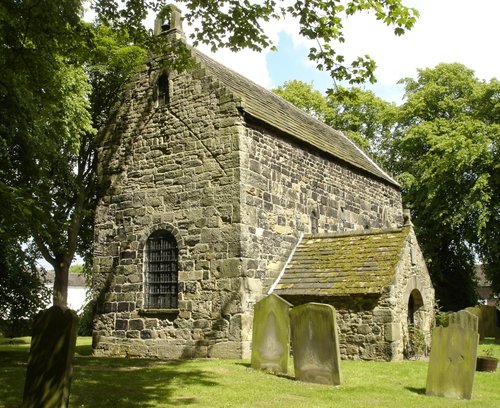
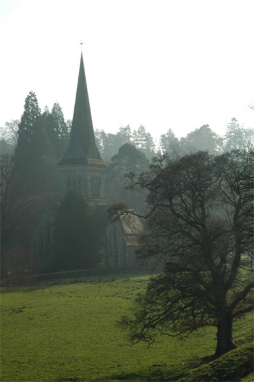
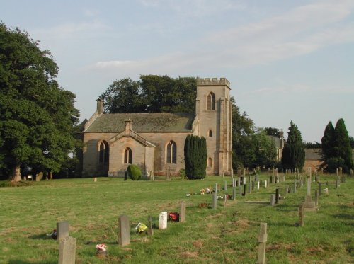
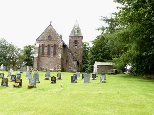
Lying in a prominent position ringed by the River Wear, Escomb is best known for its magnificent Saxon Church reputed to be built from stones brought from the near-by ruined Roman Fort at Binchester...

St Mary church, Walton, Brampton Cumbria

Brampton (26 Pictures)

in the county of Cumbria (22.8 miles, 36.7 km, direction NW)

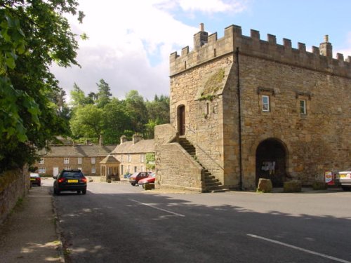
One of the loveliest features of Brampton is its octagonal Moot Hall, built by the Earl of Lancaster in 1817...

Gates leading to Meaburn Hall, Maulds Meaburn, Cumbria

Maulds Meaburn (1 Pictures)

in the county of Cumbria (23.2 miles, 37.3 km, direction SW)

Hunter Davies (famous author, journalist and broadcaster) described the village as "... one of the most beautiful villages in the country"...

Recommended attractions near Allenheads

Killhope Lead Mining Museum high in Upper Weardale. A desolate but magical place.

Killhope Lead Mining Museum (7 Pictures)

(2.8 miles, 4.5 km, direction SW)

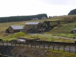
Killhope Lead Mining Museum keeps alive the counties lead mining traditions. This is a fully restored site of a working mine.....

Frosterly in Weardale, County Durham

Weardale (20 Pictures)

(4.9 miles, 7.9 km, direction SE)

This lovely scenic valley lies between the town of Bishop Auckland, seat of princes of the church and the charming market town of.....

Blanchland Abbey, Northumberland

Blanchland Abbey (1 Pictures)

(7.4 miles, 11.9 km, direction NE)

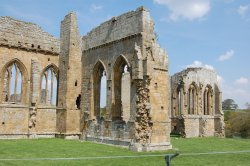
Blanchland Abbey was founded as a priory in 1165 by Walter de Bolbec II, and became an abbey in the late 13th century. The.....

High Force, Englands highest waterfall. On the River Tees, Upper Teesdale, Co.Durham.

High Force (56 Pictures)

(10.6 miles, 17.1 km, direction S)

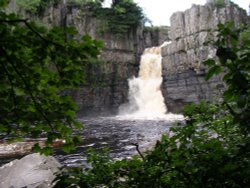
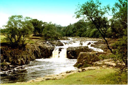
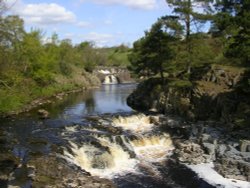
This is the Tees most spectacular offering, it is also England's highest waterfall. The best time to see High Force is just.....

Langley Castle Hotel, Tynedale, Northumberland

Langley Castle (3 Pictures)

(10.8 miles, 17.4 km, direction N)

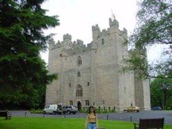
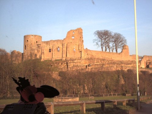
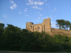
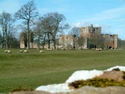
Built in 1350, during the reign of Edward III, the castle has retained its architectural integrity and is regarded as one of the.....

Hexham Abbey, Northumberland

Hexham Abbey (10 Pictures)

(12.6 miles, 20.2 km, direction N)

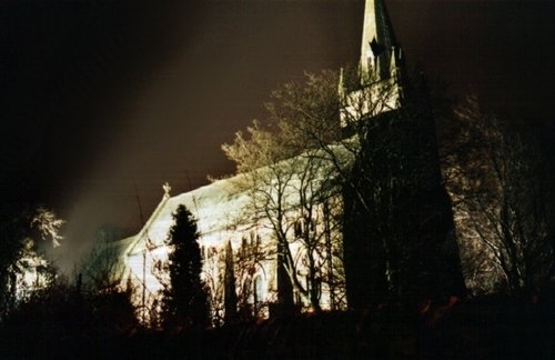
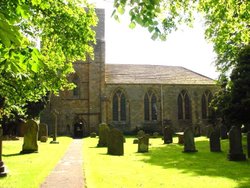
Hexham Abbey is a refoundation of a church which stood on this spot in the year 675, it survived until 821, later the town was.....

Low Force, at Bowlees on the River Tees, Upper Teesdale, County Durham.

Teesdale (20 Pictures)

(12.9 miles, 20.7 km, direction S)

..

A picture of Tyne Green Country Park

Tyne Green Country Park (1 Pictures)

(13.5 miles, 21.6 km, direction N)

..

Hadrian's Wall

Hadrian's Wall & Housesteads Fort (36 Pictures)

(15.0 miles, 24.1 km, direction N)

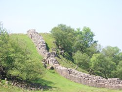
Wild and evocative remains of the Roman Empire's most northerly defences, with panoramic views. Roman barracks and some of the.....

Double rainbow

Hamsterley Forest (12 Pictures)

(15.4 miles, 24.7 km, direction SE)

Hampsterley Forest encompasses over five thousand acres, it is a combination of parkland and forest, giving access to some of the.....

The River North Tyne

Chesters Roman Fort (Cilvrnvm) (71 Pictures)

(15.7 miles, 25.2 km, direction N)

..

Mithraeum temple near Brocolitia roman fort Milecastle

Carrawburgh Roman Fort (Brocolitia) (2 Pictures)

(15.9 miles, 25.6 km, direction N)

..

Long Meg & her Daughters (Maughanby Circle)- near Penrith, Cumbria

Long Meg & her Daughters (14 Pictures)

(18.7 miles, 30.0 km, direction W)

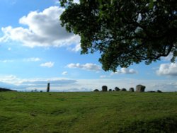
The 12 foot high mass of sandstone known as Long Meg can be found close to a circle of smaller "daughter" stones in a spectacular.....

Just before the snow arrived... -  - taken at Talkin Tarn country park

Talkin Tarn Country Park (26 Pictures)

(21.0 miles, 33.7 km, direction NW)

This lovely country park occupies a magical landscape close to the historic market town of Brampton. The icy waters forming the.....

Gibside Chapel, National trust garden - Rowlands Gill, Burnopfield, Newcastle upon Tyne NE16 6BG

Gibside (42 Pictures)

(21.0 miles, 33.8 km, direction NE)

Gibside is famous for the sedate historic estate set at the heart of the outstandingly beautiful Derwent Valley. The estate was.....

A view of the Castle at Barnard Castle, County Durham

Barnard Castle (26 Pictures)

(21.6 miles, 34.8 km, direction SE)

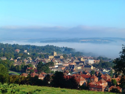
This historic town is a picturesque centre for discovering the delights of Teesdale. The town occupies a clifftop site above.....

Bowes Museum.. Near Barnard Castle...3rd October 2004.

Bowes Museum (12 Pictures)

(21.8 miles, 35.1 km, direction SE)

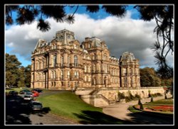
Josephine Bowes, wife of John Bowes was a Parisian actress, and perhaps this shows in the choice of building they chose as a.....

The magnificent Raby Castle, Staindrop, Co. Durham.

Raby Castle (31 Pictures)

(21.9 miles, 35.2 km, direction SE)

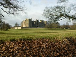
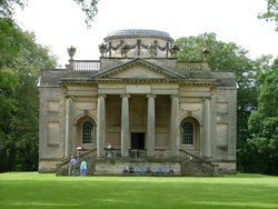
Arriving close to Staindrop from almost any direction the view of Raby Castle, built by the powerful Nevill family in the.....

Egglestone Abbey

Egglestone Abbey (13 Pictures)

(22.7 miles, 36.5 km, direction SE)

..

Brougham Castle, Penrith, Cumbria

Brougham Castle (12 Pictures)

(22.7 miles, 36.5 km, direction SW)

Coming Soon. Can you tell us about Brougham Castle? broughamcastle@picturesofengland.com..


All attractions in Allenheads
All attractions in Northumberland