'; ?>
Pictures of England

Search:

Historic Towns & Picturesque Villages

The Royal Bath's. Harrogate

Harrogate

in the county of North Yorkshire

The Pantiles at Royal Tunbridge Wells

Tunbridge Wells

in the county of Kent

Recommended Towns & Villages near Whitehaven

St Bees as seen from clifftops

St Bees (26 Pictures)

a Seaside Town in the county of Cumbria (4.0 miles, 6.4 km, direction S)

St.Bees, the most westerly coastal village on the wild cumbrian coast, is a vision of loveliness...

Workington Harbour, Workington, Cumbria.

Workington (7 Pictures)

in the county of Cumbria (6.7 miles, 10.8 km, direction N)

Ancient market town of quintessential English charm, where you could easily swap the modern day cars parked in gracious tree-lined avenues for the horse and carriage of Victorian times...

The Kirkstile Inn

Loweswater (17 Pictures)

in the county of Cumbria (10.6 miles, 17.0 km, direction E)

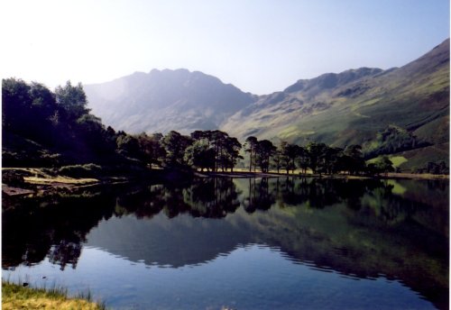
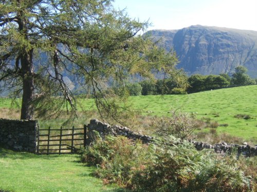
Loweswater is centred in a landscape of grandeur, it is surrounded by Mellbreak Fell, Carling Knott Fell and Burnbank Fell, all excellent climbing and walking country giving views of a mountainous landscape reflected in sun-kissed pewter waters...

The Herdwick Tup, COCKERMOUTH, The Lake District, Cumbria 2005.

Cockermouth (4 Pictures)

a Historic Market Town in the county of Cumbria (11.7 miles, 18.8 km, direction NE)

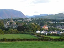
Cockermouth is ideally placed to be used as a centre for touring the Lake District National Park. It has a High Street seemingly unaltered, and is ringed by some of the finest scenery in England...

Maryport Harbour

Maryport (12 Pictures)

a Seaside Town in the county of Cumbria (12.0 miles, 19.3 km, direction N)

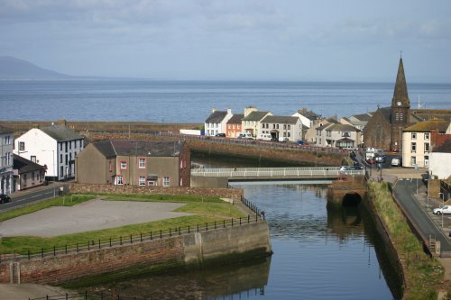
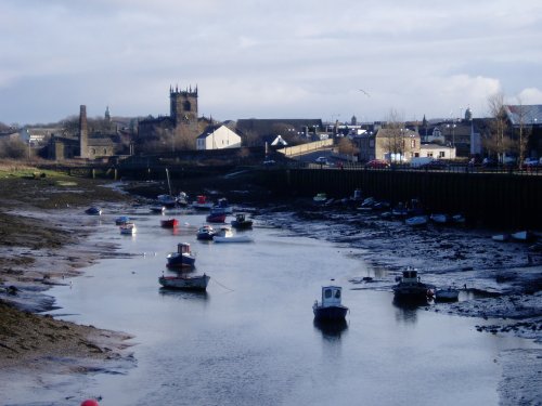
Today, first and foremost Maryport is a splendid resort town on the beautiful Solway coast, it is steeped in the maritime history of two thousand years of sea...

Buttermere, Cumbria, Haystacks and the path to Scarth Gap (clearly visible)

Buttermere (102 Pictures)

in the county of Cumbria (12.6 miles, 20.2 km, direction E)

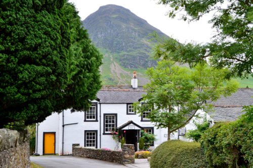
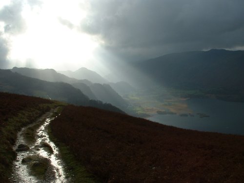
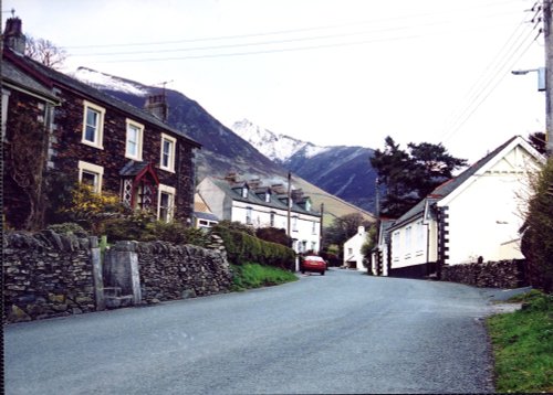
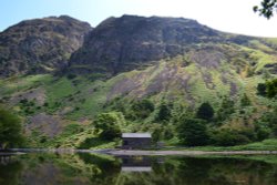
Even when swirling mist rolls in over the stark fells surrounding Buttermere, the little hamlet remains serene in its simplicity and beauty...

Gentle farmland of lower Wasdale with the dramatic backdrop of the screes.

Nether Wasdale (4 Pictures)

a Picturesque Village in the county of Cumbria (13.1 miles, 21.1 km, direction SE)

Nether Wasdale lies opposite Wasdale Head at the western fringe of Wast Water...

Wasdale walk

Wasdale Head (42 Pictures)

in the county of Cumbria (14.8 miles, 23.8 km, direction SE)

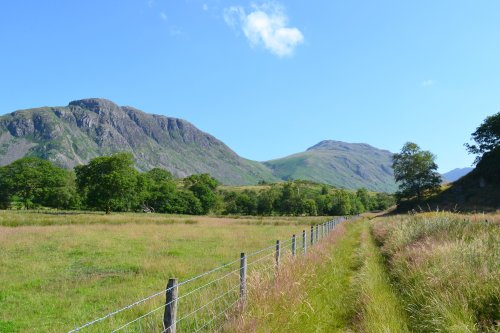
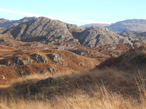
Vast, lonely landscape of towering fells, jewel like streams and tarns situated at the head of the Wasdale Valley with the mighty Scafell Pike, England's highest mountain and Great Gable forming an almost uniformity range of mountains in the distance...

Ravenglass sunset

Ravenglass (40 Pictures)

a Seaside Town in the county of Cumbria (15.3 miles, 24.7 km, direction SE)

Special for being the only coastal village within the Lake District National Park, Ravenglass lies where three important rivers converge into the sea...

Looking down on Eskdale, Cumbria, on a crisp November morning.

Eskdale Green (26 Pictures)

a Picturesque Village in the county of Cumbria (15.4 miles, 24.8 km, direction SE)

..

On the tops above Boot, Eskdale, Cumbria.

Boot (7 Pictures)

a Picturesque Village in the county of Cumbria (16.3 miles, 26.3 km, direction SE)

Boot is one of Lakeland's precious jewels, a charming stone village surrounded by towering scenery which includes two of the regions most scenic waterfalls, the Dalegarth Force and Birker Force...

Grange in Cumbria

Grange in Borrowdale (15 Pictures)

a Picturesque Village in the county of Cumbria (17.5 miles, 28.2 km, direction E)

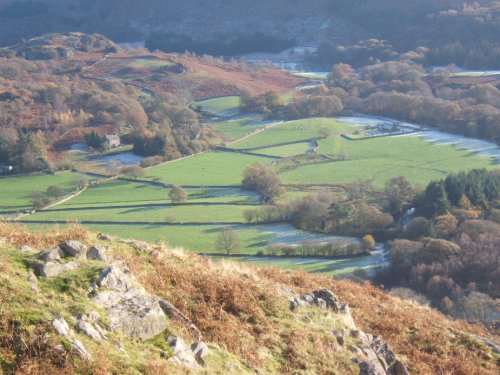
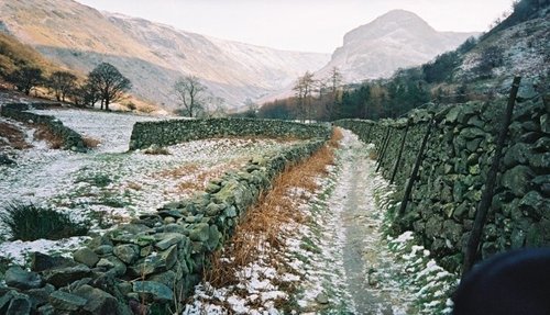
A picturesque village in the Borrowdale valley, one of the most beautiful valleys in England...

Walla Crag - Borrowdale - Lake District

Borrowdale (38 Pictures)

in the county of Cumbria (17.7 miles, 28.4 km, direction E)

There is little doubt that Borrowdale possess some of the most unforgettable of all in the vast landscape of The Lake District National Park...

Heron Crag in the Langstrath Valley  near Smithymire Island and Stonethwaite Borrowdale

Stonethwaite (5 Pictures)

a Picturesque Village in the county of Cumbria (18.2 miles, 29.3 km, direction E)

Tucked away in a quiet part of Borrowdale where streams tumble down crags amongst a patchwork of old pack-horse trails, scenery does not come more beautiful than that which surrounds this peaceful hamlet in the Langstrath Valley...

Lake Bassenthwaite from the west bank.

Bassenthwaite (39 Pictures)

in the county of Cumbria (18.3 miles, 29.4 km, direction NE)

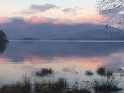
This is the most northerly of all the lakes, it resembles beaten silver nestling between the sun dappled heights of soaring fells and mountains. Almost at its shores are Barf,.....

Tiny Village

Watendlath (28 Pictures)

in the county of Cumbria (18.8 miles, 30.2 km, direction E)

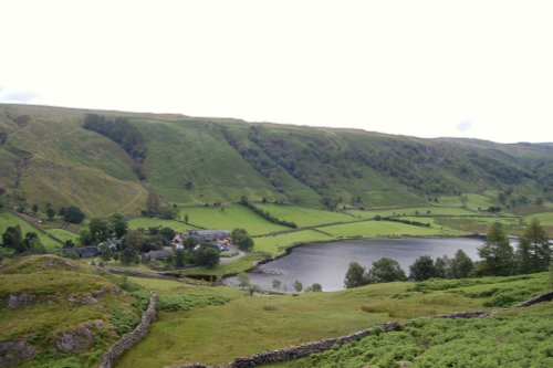
A place of great beauty, Watendlath's dramatic landscape inspired writer Sir Hugh Walpole to choose it as the setting for his Rogue Herries series...

Derwentwater.

Keswick (465 Pictures)

a Historic Market Town in the county of Cumbria (18.9 miles, 30.4 km, direction E)

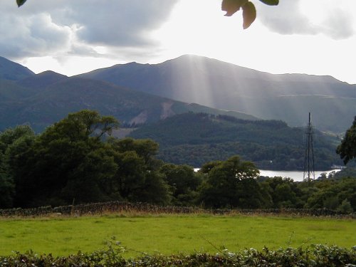
Keswick is a pretty Market Town that nestles between the spectacular Skiddaw Mountains and the northern end of the serene Derwentwater Lake within the Lake District National Park.....

From Castlerigg Farm Campsite, looking towards Cat Bells. Lake District

Castlerigg (10 Pictures)

in the county of Cumbria (19.5 miles, 31.3 km, direction E)

Castlerigg is a favoured destination for tourists, it is easily accessible from the market town of Keswick and is within easy reach of the snaking waters of the pretty River Greta, picturesque becks and fells...

Mid Duddon Valley from the top of the lane between Broughton Mills and Hall Dunnerdale, Cumbria.

Hall Dunnerdale (2 Pictures)

a Picturesque Village in the county of Cumbria (20.7 miles, 33.3 km, direction SE)

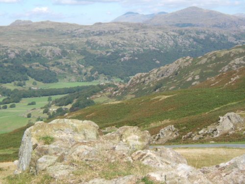
Scenery does not come much finer than the scenic beauty surrounding the Valley of the River Duddon where you will find the delightful hamlet of Hall Dunnerdale...

Threlkeld Village, Cumbria, with Blencathra (Halls Fell and summit)

Threlkeld (12 Pictures)

in the county of Cumbria (21.9 miles, 35.3 km, direction E)

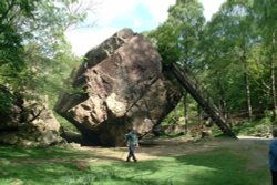
This is a magical area of sparking lakes, tumbling waterfalls, high peaks and vast moorland regions...

Recommended attractions near Whitehaven

St Bees Head in Cumbria

St Bees Head (7 Pictures)

(3.7 miles, 5.9 km, direction S)

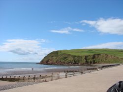
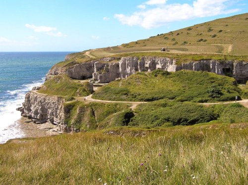
These are the only cliffs on the coast of Cumbria, and it here visitors can catch a glimpse of the sheer drama of sea-birds, for.....

Crummock Water, Lake District, Cumbria.

Crummock Water (37 Pictures)

(11.4 miles, 18.3 km, direction E)

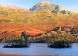
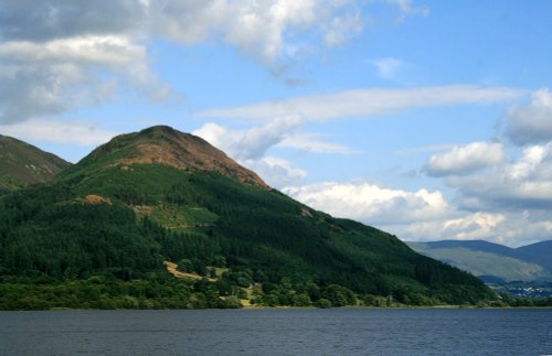
The romantic setting between high fells gives Crummock Water its character. It is somewhat overshadowed by other better known.....

General view showing Cockermouth Castle and Jennings Brewery, Cumbria

Cockermouth Castle (1 Pictures)

(12.0 miles, 19.4 km, direction NE)

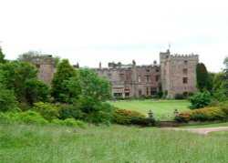
These wonderful ruins of a by-gone age can be discovered in the charming inland resort of Cockermouth, amongst Lakeland's.....

Wast Water

Wast Water (37 Pictures)

(14.2 miles, 22.9 km, direction SE)

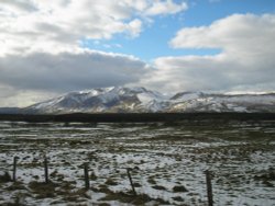
Wast Water is the deepest lake in England at 280 feet deep. The awesome peaks of Sca Fell and Great Gable tower over the wild,.....

A picture of Whinlatter Forest Park

Whinlatter Forest Park (7 Pictures)

(15.3 miles, 24.6 km, direction E)

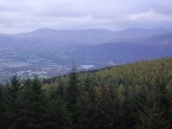
If you happen to visit Keswick in Cumbria do not miss out on Whinlatter Forest Park, for this superb gift of nature is a real.....

Muncaster Castle, Cumbria

Muncaster Castle (33 Pictures)

(15.9 miles, 25.6 km, direction SE)

..

A picture of The Bowder Stone

The Bowder Stone (6 Pictures)

(17.5 miles, 28.1 km, direction E)

..

Derwentwater as the daylight starts to go

Derwentwater (424 Pictures)

(18.3 miles, 29.5 km, direction E)

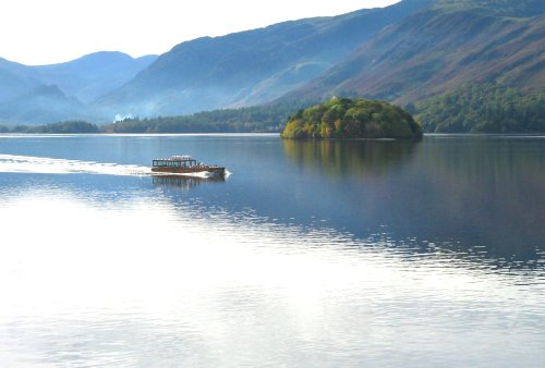
Derwentwater is one of 16 Lakes set within the Lake District National Park in Cumbria. It is one of the most northerly of the.....

Hardknott Roman Fort( Lake District )19th June 2005

Hardknott Roman Fort (3 Pictures)

(18.3 miles, 29.5 km, direction SE)

..

Castlerigg Stone Circle

Castlerigg Stone Circle (41 Pictures)

(20.1 miles, 32.4 km, direction E)

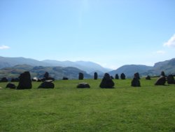
The best time to view Castlerigg Stone Circle is that eyrie time when night is just giving way to dawn. It is then, with a.....

A view of Langdale Pikes, Little Langdale, Cumbria from Tarn Hows.

Langdale Pikes (44 Pictures)

(20.3 miles, 32.7 km, direction E)

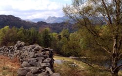
These famous pikes rise loftily above the village of Langdale, whilst below visitors can savour the wild and desolate beauty of.....

The Lake District

The Lake District (1476 Pictures)

(21.2 miles, 34.0 km, direction E)

I first saw the Lake District many years ago, when for eight out of my eleven day sojourn, it rained, and rained! None-the-less,.....

Holme Cultram Abbey, Abbey Town, Near Silloth, Cumbria

Holme Cultram Abbey (6 Pictures)

(23.8 miles, 38.3 km, direction NE)

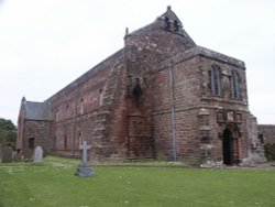
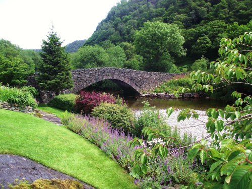
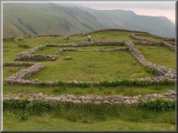
This was a Cistercian foundation of the 12th century of which the nave is now the parish Church of St.Mary, and although the.....


All attractions in Whitehaven
All attractions in Cumbria